
Today, all ERDAS TITAN Clients participating on the public TITAN Network will automatically update to version 9.3.2d. This update includes fixes for:
* KML optimization that accelerates rendering of vectors with many features or vertices
* Fix for KML shadowing properties
The auto-update will occur the next time you log into the public ERDAS TITAN Network with your TITAN Client.
Thursday, December 18, 2008
ERDAS TITAN Client Update: includes faster vector rendering!

Tuesday, December 16, 2008
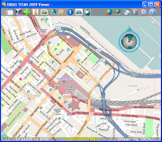
OpenStreetMap and ERDAS TITAN for Broad Global Basemap Coverage
I'm buzzing a lot about incorporating OpenStreetMap (OSM) as the default basemap in the TITAN Viewer because we are especially excited to have the opportunity to make available to TITAN users this unique, free source of data contributed to by "community cartographers" around the globe.
The blogosphere is rich these days with comparisons hailing the OSM global dataset as 'better than' that of other corporate competitors in many areas. SlashGeo points to some comparisons here. This is so interesting since contributions to OSM are made by a volunteer force; no corporate machine feeds this source!
In a November post Ogle Earth blog zooms in on Baghdad to show OSM having the best coverage and "going where big corporate mapping datasets fear to tread." In Baghdad all other maps but OSM are sparse at best, as illustrated in this post.
ERDAS TITAN 2009 Now Supports OpenStreetMap press release was issued today. Below is a screenshot of OSM in the TITAN Viewer.
Monday, December 15, 2008
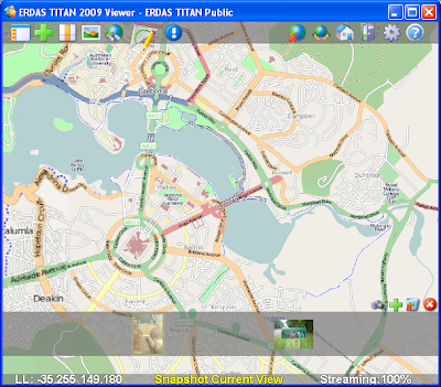
Use Your Own Data as Basemaps and Terrain in the TITAN Viewer
Ryan at The Fiducial Mark has been busy hosting webinars such as "3D City Construction Workflows: From Collection to Presentation" and also making interesting posts showing how to make the most out of the ERDAS TITAN Viewer for modeling 3D urban spaces. In two separate posts he describes how you can use your own personal, local data as either 1. basemap or 2. terrain in the TITAN Viewer.
1. First is the post on Defining Your Own Raster Basemap in ERDAS TITAN:
Most virtual worlds have pre-cooked imagery that they serve up as their "skin of the earth" basemap. But what if I want to define my own default imagery, just for my own personal use?
Here Ryan walks easily step by step to show you how to turn your own datasets into basemaps in the TITAN Viewer. He added a picture displaying results:

2. Ryan deals in photogrammetry and highly accurate data. In another post he describes how terrain available in many virtual globes are too coarse and inaccurate to properly display 3D buildings extracted from photogrammetric processes. In a post on 3D Buildings and Terrain in Virtual Worlds Ryan points out that the latest release of ERDAS TITAN has a good technique for sorting out this problem by allowing you to specify your own local raster datasets as terrain layers:
In this case I processed my own digitial orthomosaic along with a terrain layer during the photogrammetric processing part of the project. I added the digital elevation models as layer, right-clicked on it and chose the "use as terrain" option....The result is that the (3D KML) buildings sit perfectly on top of the terrain.
Here's a screenshot of floating buildings:

And here's a screenshot in the TITAN Viewer with an accurate, locally added terrain source and the buildings sitting properly on the ground:

Thanks for the How-To along with the posts Ryan!
Thursday, December 4, 2008
ERDAS TITAN Client 9.3.2c Released!
We have made some exciting changes to the ERDAS TITAN Client! New features in ERDAS TITAN Client 9.3.2c include:
- OpenStreetMap is the default basemap. This collaborative, free global map project is now available as the default basemap option in the TITAN Viewer. For more information on OpenStreetMap, please visit http://www.openstreetmap.org/
- Multi-Screen Support allows you to span one TITAN Viewer display across multiple PCs/ screens, creating the illusion that the numerous displays are one contiguous display.

TITAN spans multiple screens at Arizona
State University's Decision Theater.
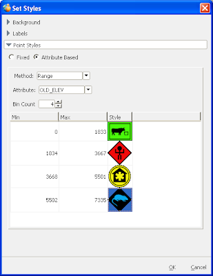
- Attribute based symbology for point vectors in the TITAN Viewer and a default DHS symbol set.
- Locally add multiple DEMs as terrain sources in the TITAN Viewer.
To see a list of all the enhancements, please see ERDAS TITAN Client Update 1 – Version 9.3.2c What’s New.
Friday, November 21, 2008
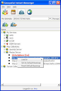
Basemap Improvements coming to ERDAS TITAN
In the next few days, we will be making some exciting changes to ERDAS TITAN.
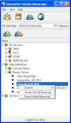
During this transition, you may need to change your default basemap in the TITAN Viewer. You can do this by following these simple instructions:
1. Select the Services tab in the Geospatial Instant Messenger (GeoIM)
2. Expand Map Collections/Master Server
3. Choose from three global coverages:
- Topography_003.tif.lr
- naturalearth.tif.lr
- world.topo.bathy.200407.3x5400x2700.tif.lr
4. Right click on a coverage and select ‘Set As Default Basemap”
5. Close and reopen your TITAN Viewer (reopen Viewer from GeoIM: File/Launch TITAN Viewer)
OpenStreetMap (OSM), a collaborative global map project, will be your default basemap in a TITAN Client auto-update next week.
Thank you for being a part of the ERDAS TITAN Community!
Thursday, November 20, 2008
Professors! Hassle-free data delivery to your students!
Paul at The Field Guide points out how useful TITAN would have been during his time at Georgia Tech.
Paul also points out that the ERDAS 2009 DVD Media Kits containing all ERDAS software and data examples for all ERDAS products are currently shipping!
Wednesday, November 12, 2008
TITAN goes Multi Screen!
This fall update to TITAN includes support for Multi Screens: spanning one TITAN Viewer display across multiple screens. In a multi-screen environment, many screens display the output of one computer and create the illusion that the numerous displays are one contiguous display. TITAN multi screen support will include both flat wall displays and also immersive environments.
Check out TITAN across 3 screens in ASU's Decision Theater:
"The ASU Decision Theater consists of an interactive 3D immersive environment
built with cutting edge graphics technologies. The core component, called the
Drum, is a 260-degree faceted screen that can display panoramic computer
graphics or 3D video content."
Look for Multi Screen support this fall as a feature in the free TITAN Client!
Tuesday, October 28, 2008
Local Government GIS Collaboration & TITAN
I had the pleasure of presenting the ERDAS TITAN solution at the Georgia URISA Conference a couple of weeks ago. This biennial statewide GIS conference is hosted by an organization dear to my heart (I served on the Georgia URISA board for five years with one term as President).
I also had the pleasure of having Joe Woycke, Cherokee County Director of GIS and Derrick Smith, GIS Manager of the City of Woodstock present after me in the same session. Joe and Derrick are working very hard to develop collaborative GIS between city and county, and in their presentation they described how TITAN proves to be 'one of the most effective means of quickly sharing and visualizing data without surrendering ownership of the data.'
Joe Woycke describing the utility of ERDAS TITAN in collaborative GIS:
County and municipal governments in Cherokee County have begun collaborating in the development of a collaborative GIS. Key to these relationships is the ability to quickly share current up to date data while retaining ownership. Many different software packages have been used to transmit and share data. ERDAS TITAN has proven to be one of the most effective means of quickly sharing and visualizing data without surrendering ownership of the data. The use of mash ups utilizing data from several different sources presented to the consumer in single client map provides great value to consumers (the taxpayers), who are not concerned about jurisdictional issues and petty parochialism. Current efforts are focused on efficiently serving and updating data with minimal overhead in terms of labor and bureauocracy, a task which TITAN is uniquely well suited for. The result is a more comprehensive GIS providing a cost savings and enhanced convenience to the citizens. Future development will be focused on providing a unified GIS to support emergency management operations, adding another aspect to the value added nature of this GIS collaboration.

Thursday, October 23, 2008
Browse TITAN Users and Data in ArcMap
Check out the new video TITAN ArcMap Extension (also available here on this blog under Product Demonstration Videos)
Browse users and load ERDAS TITAN data directly within ESRI's ArcMap. This TITAN extension to ArcGIS embeds the GeoIM as a dockable list of TITAN users and their data shares directly in the ArcMap user interface.

Extension is available here under Downloads.
ERDAS at GEOINT 2008
ERDAS will be at GEOINT 2008 Symposium, October 27-30, 2008 at the Gaylord Opryland Resort and Convention Center in Nashville, Tennessee. ERDAS and Oracle will be co-hosting the welcome reception, in the plaza between the Grand Ole Opry and the Grand Ole Opry Museum, on October 27 from 7-9 p.m.
Exhibiting in Booth #942, ERDAS is featuring ERDAS TITAN along with recently announced ERDAS APOLLO 2009 and the latest releases of ERDAS IMAGINE and LPS. Stop by the booth for demos of all the latest TITAN features.
Thursday, October 9, 2008
TITAN in Italy
In their October 2008 newsletter, ERDAS Italian distributor Planetek Italia writes:
ERDAS TITAN: the Italian Geospatial Community
The TITAN Network has its Italian Geospatial Community. Through its webportal, enriched with several tools such as forum, news, a geodata section and tutorial, Italian business professionals and surfers can rapidly learn, download and use ERDAS TITAN, connecting to the Italian GeoHub. The application is designed for those organizations and working groups who need to share geospatial or location-based contents in a single secure environment and want to benefit from real-time interaction. For Italian users, details and download are available at: http://titan.planetek.it/
We're proud to have the Planetek Italia GeoHub on the TITAN Network!
Monday, October 6, 2008
ERDAS TITAN 2009 Release
We are very pleased to announce the release of ERDAS TITAN 2009 (version 9.3)!
Today is an historic day for ERDAS marked by major releases across all product lines. This full product line release is complemented by a major overhaul of http://www.erdas.com/, providing a broad scope of interactive information including demo movies, screenshots, white papers and case studies, technical documents, product downloads and new licensing.
The theme of ERDAS TITAN 2009 is interoperability: ERDAS TITAN 2009 now extends the TITAN experience into additional geospatial applications, allowing users to browse and load shared data directly within ERDAS IMAGINE and ArcGIS. An SDK is also provided to support embedding the IM experience into other geospatial applications as well. Data format support is extended for a select set of ERDAS IMAGINE raster formats and sensor models, available when ERDAS IMAGINE 9.3 is installed on the same machine. Support has been added for querying a catalog and accessing layers made available as web services in ERDAS APOLLO. Appropriate for a global audience, the ERDAS TITAN Client is now localized for some languages, with a Translator Tool for any language.
Other improvements include:
- Map Collections: A Services Panel in the GeoHub Admin tool allows the administrator to add layers to and manage Map Collections that are available to connected subscribers via TITAN Clients. Using the Master Server Admin Tool, an administrator can add sources for both basemaps and terrain for use by the entire network. TITAN users may access and utilize these map and terrain collections via TITAN Clients.
- ECWP upgrade, for faster reading of ECWP
- Proxy file load for direct data load into ERDAS IMAGINE Viewer
- TITAN Viewer Layer panel redesign displays data owner and permissions
Support of KML in Viewer now includes color styles, placemarks, geometry, regions, stylemaps, and network links - Uniform styles management across applications
- Right click to create one web service with all the layers a user is sharing, or just with a selected file
- Search results include private data and KML
- Password management
- Band combinations adjustments
- Disable 2 standard deviation preference
- Start IM in tray preference so that TITAN starts minimized to the tray when Windows starts
Tuesday, September 30, 2008
See the Webinar Here
Roger Longhorn of GEO:connexion attended the first TITAN webinar on Thursday September 25. He has written a review about what was presented, as well as posted the link to play the webinar: http://www.geoconnexion.com/geo_news_article/ERDAS-TITAN-Webinar/4387.
The webinar link is: https://erdasevents.webex.com/erdasevents/lsr.php?AT=pb&SP=EC&rID=1118387&rKey=CD2648A78BC12F1C
Wednesday, September 17, 2008
Running the TITAN Client in Linux
TITAN is about sharing data and even brings a lot of the DNA from social networking websites into the realm of geospatial data sharing. The value of a social network lies in the number of people who are able to access it and participate in discussion. Linux OS is frequently used for a variety of scientific applications which produce geospatial data. So given these facts we wanted to see if the TITAN Client would run on Linux, and begin to include the community of geospatial people using Linux on the client side.
The short answer is yes, the TITAN Client will run in Linux, but it has a prerequisite. In whatever distribution of Linux you have running, you will need to have access to the Windows API within Linux. The most common way to do this is to have Wine (http://www.winehq.org/) installed. Wine is a translation layer that has been around since 1993 and allows Windows programs to be run on a Linux machine natively, not through an emulator which usually affects memory and processor usage. You can get more information about Wine from its official website, Wine HQ. There you can find instructions on how to get Wine running on your Linux machine and also how to install Windows programs through Wine, which you’ll need since the TITAN installer is Windows-only.
We went through that process using the Ubuntu distribution of Linux and successfully got TITAN running, which you can see in the screenshot below.
The process was pretty painless, which we were expecting since most of the libraries used to build TITAN originated in Linux. If you’d like to see TITAN running in Linux, but don’t want to take the time to install Linux on a spare computer, we’ve provided a virtual machine instance of the same Ubuntu Linux we used to install TITAN. To run this, you’ll need to install either VMware Player or Server (which you can download or get more information from here - http://www.vmware.com/products/player/) and download the virtual machine from our FTP Server. If you have access to an FTP client, you can go to ftp.nvs-inc.com and log in with the user name and password of "titan." If you want a direct link to the file, you can use ftp://titan:titan@ftp.nvs-inc.com/TITANLinux.zip. The file is compressed down to 952 mb and takes up a little more than 2 gb when it's completely uncompressed, so it will take a while to download and also take up a pretty big chunk of hard drive space.
Once you’ve downloaded the zip file and extracted its contents, double-click the file named Ubuntu.vmx and VMWare should start up. You may be asked if you moved the Virtual Machine (VM), say “yes” and everything should load up just fine. The login user name and password for Ubuntu are both "user." There’s a shortcut on the desktop to start TITAN, so double-click that and you’re using TITAN in Linux (you’ll need to provide your TITAN login credentials, though).
And if you have any doubts of TITAN running in Linux, here’s a bit of trivia: the TITAN developer is named Lennox, so it should automatically work anyway. Next, we’ll try and get TITAN running on a Mac!
This article was co-written by Joel Lawhead and Joel Herr of NVision Solutions, Inc.
Joel Lawhead is the CIO of NVision Solutions, Inc. and has been involved in GIS since late 2000.
Since 2003, Joel Herr has worked for NVision Solutions, Inc., first as a GIS Analyst and currently as a GIS Specialist. He works heavily in analysis, training, production, and web application development.
NVision Solutions, Inc. is a small, disadvantaged, minority, woman-owned certified 8(a) firm specializing in advanced geospatial solutions and powerful web applications. NVision Solutions, Inc. has also assisted in several ERDAS TITAN installations and has selected it for use in emergency management and disaster recovery. NVision is headquartered at the Stennis Technology Park in Bay St. Louis, Mississippi. For more information about NVision Solutions, Inc., visit www.nvisionsolutions.com.
Friday, September 5, 2008
Map Collections, Server Side...
Via a TITAN GeoHub, organizations can now provide web service layers as maps to their subscribers via Map Collections.
The GeoHub Admin can add layers from WMS, WCS and ECWP to the Map Collection, and can provide access to ERDAS Apollo Image Manager (EAIM) catalogs of data exposed as web services. The Admin can also add web service layers and datasets that are published by the subscribers themselves, with permissions on those datasets maintained.
In an autonomous network, the Master Server Admin is enabled to provide layers from WMS, WCS and ECWP sources in a Map Collection as well. Beyond that, Master Server Admins can create custom tiled versions of imagery and terrain datasets for delivery from standard web servers to TITAN Clients participating in their network. They can pre-process their own basemap imagery for faster streaming of data via a custom TITAN Tiled Basemap, and can also generate a TITAN Tiled Terrain source, a custom tiled version of a terrain source which can be streamed to clients on a block by block basis.
Ultimately it’s the users that benefit from these sources of data, with more selection for basemaps and terrain for their TITAN Viewer.
Thursday, September 4, 2008
Upgrade!
The ERDAS TITAN Network was upgraded last night to ERDAS TITAN 2009! This means that your ERDAS TITAN Client will have updated too with great new features!
I am also pleased to inform you of the upcoming release of ERDAS TITAN 2009 (version 9.3) server products, including ERDAS TITAN GeoHub, ERDAS TITAN Master Server and ERDAS TITAN Web Cache Servers, which will be available early September.
Here's what's new in the ERDAS TITAN Client
- ERDAS Apollo Image Manager (EAIM) Catalog support for authenticating with and querying, discovering and accessing data as web services from ERDAS Apollo Image Manager (EAIM) Catalog.
- Data format support is extended for a select set of ERDAS IMAGINE raster formats and sensor models, available when ERDAS IMAGINE 9.3 is installed on the same machine. Support includes NITF and also TFRD (TFRD when Defense Productivity Bundle is also installed).
- Localize the TITAN Client to different languages. The TITAN Client comes equipped with a Translator Tool for any language, and is now already localized for some languages.
- Utilization of Basemaps and Terrain: GeoHub Admins can designate different sources of basemaps for their subscribers, and Master Server Admins can designate different sources of basemaps and terrain for network users. So, TITAN users may now utilize different sources of basemaps and terrain in TITAN Viewers!
And more....
- ECWP faster implementation, for fast reading of ECWP.
- Proxy file load for direct data load into ERDAS IMAGINE Viewer
- TITAN Viewer Layer panel redesign shows data owner and permissions.
- The TITAN Viewer now supports KML with color styles, placemarks, geometry, regions, stylemaps, and network links.
- Uniform styles management across applications
- Right click to create one web service with all the layers a user is sharing, or just with a selected file.
- Search results include private data and KML
- Password management
- Band combinations may be adjusted for raster datasets in the IM, for individual or multiple datasets at a time.
- Disable 2 standard deviation preference
- Start IM in tray preference so that TITAN starts minimized to the tray when Windows starts.
Get the download here. Work is still being finalized on a new ERDAS website, and currently the redirect is still to our former incarnation 'Leica Geosystems Geospatial Imaging' for now.
Tuesday, August 19, 2008
New Movies and Papers
See new movies and links to white papers about TITAN in the column on the right (of the ERDAS TITAN Blog). The movies show a lot of detail regarding what is to come in the August release of TITAN!
Thursday, August 14, 2008
Four Seconds to Save the World (ERDAS TITAN 2009)
Join me on September 25 at 11 am or 8 pm EST to learn about exciting new features in ERDAS TITAN 2009!
Register here: Four Seconds to Save the World
ERDAS TITAN 2009 rapidly enables multitudes of stakeholders to publish and consume geospatial data and location-based content in one online, collaborative network. When every second counts, users can consume data from multiple public and private sources into a variety of virtual globe, internet and rich client applications. This webinar will highlight this timely, unique permission-based tool, illustrating support of additional services and interoperability with ERDAS IMAGINE®, ERDAS Image Web Server, ERDAS APOLLO and ArcGIS.
Monday, August 11, 2008
Using Shared TITAN Layers with ArcGIS Server
In an earlier post, it was mentioned that ERDAS TITAN could be used as a proxy to bypass the limitations of data ingestion within many geospatial applications. This tutorial will attempt to demonstrate this idea. For this tutorial I decided to share data from a TITAN Client on my workstation to the TITAN Client on my ArcGIS Server machine. I did this so I could go through the complete process of consuming published datasets as well as being able to pull the TITAN WMS URL for that data into ArcGIS server and serving it out as a web application. This process let me control all aspects of the data I published, but the process will work for any published layer in TITAN.
Why is this useful? Using TITAN to publish datasets as WMS and then consuming and ultimately publishing them into a web application with ArcGIS Server decentralizes the data. For example, the traditional method of creating a web application entailed pulling data from a central server or database. With the WMS layers being provided by any TITAN user, no data needs to be stored locally on the server itself. You can directly consume the WMS layers into ArcMap and publish the map document you create from them.
Additionally, the speed of sharing and publishing the data via TITAN relieves you of data transfer time and storage needs, since you are accessing the data from someone else’s TITAN instance. Since TITAN creates the WMS URL by default, you only have to copy the address rather than write a custom application or have an in-depth knowledge of the WMS specification.
The first caveat is that a TITAN Client must be running on the same computer/server that ArcGIS Server is installed. This is a “must” because TITAN serves out WMS layers through a localhost address, so trying to access the WMS that resides on a separate workstation from the server will not work.
To start, I loaded the data I wanted to share into TITAN on my workstation. Figure 1 shows the datasets that I published in the Geospatial Instant Messenger. I’m logged in with my personal username (i.e. see ‘jherr’ at the bottom of the IM) in this case and I’m accessing our NVision GeoHub. The data visible in this Instant Messenger screenshot are some county-wide layers we use in various projects. The original data format, as you can see, was a shapefile. The first layer is an accurate road network and the second layer holds building footprints from 2006, just following Hurricane Katrina.
 Figure 1 - Data loaded into TITAN
Next, I set the permissions for the two datasets to public so people could actually see what I was sharing. In this case, I just defaulted to setting both layers to Public (figure 2).
 Figure 2 - Setting permissions for shared data
After the permissions were set, I set the styles for each layer. This step is more of a personal preference as I wanted to control how the layers would display on another user’s system. For the roads I made the lines black and as thin as possible. For the building footprints, I set the layer to fill the polygons with a light orange color and border them with a darker orange.
 Figure 3 - Setting the styles of the layers
These first three steps are standard tasks when adding data into TITAN, nothing really out of the ordinary, but I wanted to document them as part of this tutorial process. The following set of steps is the real meat of this tutorial. At this point everything is done on the server machine that houses ArcGIS Server. Also as a prerequisite, ArcGIS Desktop should be installed on the machine for reasons that will soon become evident.
The first thing I did on the server install of TITAN is find the shares and get the WMS URL of each. You can do this by right-clicking on the shared layer and choosing “Copy WMS URL.” If you were to paste this link somewhere, you’d see that the address starts with http://127.0.0.1:8090. This is the reason TITAN needs to be on the ArcGIS Server machine, because the 127.0.0.1 is synonymous with “localhost” and cannot be accessed from a different computer.
The first thing I did on the server install of TITAN is find the shares and get the WMS URL of each. You can do this by right-clicking on the shared layer and choosing “Copy WMS URL.” If you were to paste this link somewhere, you’d see that the address starts with http://127.0.0.1:8090. This is the reason TITAN needs to be on the ArcGIS Server machine, because the 127.0.0.1 is synonymous with “localhost” and cannot be accessed from a different computer.
 Figure 4 - Getting the WMS URL on the server TITAN
The next step is to pull this WMS layer into ArcGIS. You can do this a couple of ways. One is to open ArcCatalog and add the layer into the GIS Servers area of the table of contents (toward the bottom of ArcCatalog’s contents). In there you can click Add WMS Server and it will prompt you for the WMS URL. Paste the URL you copied from TITAN and click the Get Layers button. You should see the information about the WMS layer. When you click OK, it will be added to your GIS Servers. You can change the name to something more meaningful if you’d like. I left it as the default.
 Figure 5 - Pull the WMS layer into ArcGIS
At this point the WMS layer is now usable by ArcMap. If you want to bypass using ArcCatalog to connect to the WMS, you can do that through ArcMap by going to Add Data and scrolling down to GIS Servers in the Look In: dropdown box and selecting Add WMS Server. From there the instructions should be the same as above. I added some layers into ArcMap that cover the same area as my WMS layers. I then added the WMS layers that I had into ArcMap and made sure that everything displayed correctly. You could open an empty map in ArcMap and only add the WMS layers and it should still work correctly.
 Figure 6 - Use WMS in ArcMap Figure 6 - Use WMS in ArcMap |  Figure 7 - View WMS in ArcMap Figure 7 - View WMS in ArcMap |
Once you save the MXD with the WMS layers in it, you can publish it as an ArcGIS service. I published it through the ArcGIS Server Web Manager. For the resource type, choose “map” and browse to where you saved the MXD and give the service a meaningful name. Mine is titled “titan_wms_and_basemap.”
 Figure 8 - Publish ArcGIS Service
Now that you have an ArcGIS map service, you can build a web application using that service. In the ArcGIS Server Web Manager, choose to create a web application, name it and give it a description if you’d like, and add the services you want in the web application. I just added the service I created with the WMS layers in it, but you can add more if you have some in mind.
 Figure 9 - Add map service to web application
Continue through the wizard until your web application is finished. It’s not completely done yet, though. You will need to deploy the web application to make it viewable in a browser (and to the public as a result). Find your web application in the list and click the check box. Now click Deploy at the top and your web application will deploy after a little bit of processing. If you now click the web application name, it will give you a web address that you can click to see your newly-completed web application. Figure 10 has my example.
 Figure 10 - Check out your web application
If you want to view my working example ArcGIS Server Web Application, click here: http://vmserver.nvs-inc.com:8399/titan_test/.
Since 2003, Joel Herr has worked for NVision Solutions, Inc., first as a GIS Analyst and currently as a GIS Specialist. He works heavily in analysis, training, production, and web application development.
NVision Solutions, Inc. is a small, disadvantaged, minority, woman-owned certified 8(a) firm specializing in advanced geospatial solutions and powerful web applications. NVision Solutions, Inc. has also assisted in several ERDAS TITAN installations and has selected it for use in emergency management and disaster recovery. NVision is headquartered at the Stennis Technology Park in Bay St. Louis, Mississippi. For more information about NVision Solutions, Inc., visit www.nvisionsolutions.com.
Friday, August 8, 2008
Query Apollo from TITAN
Just last month ERDAS announced ERDAS APOLLO 2009, a new generation Geospatial Business System that provides a robust SOA environment. Apollo finds, describes, manages and provides rapid delivery of unprecedented volumes of geospatial information to domain specific desktop and web client applications. Compliant with the Open Geospatial Consortium (OGC) and International Organization for Standardization (ISO), ERDAS APOLLO implements WMS, WCS, WFS, WFS-T and CS-W standards and the ECWP and JPIP wavelet streaming protocols.
And....with the upcoming release of TITAN 2009....TITAN users will now be enabled to query the ERDAS Apollo Image Manager (EAIM) and discover datasets published through OGC web service interfaces, directly from TITAN Clients. Support includes:
Query an EAIM catalog to retrieve layers exposed through a web serviceFor TITAN 2009 August release we have built support for authenticated WMS via custom code, where previously we were using GDAL for WMS support (we still use GDAL for support of many data formats). Support for authenticated WCS is planned as well as other varieties of web services through which Apollo exposes data.
Query metadata using keywords, spatial extent, and date and time
Support for authentication
Support for scale dependent security for WMS layers

This also means that, along with all the other sources of data they manage in their TITAN Client, TITAN users can now discover and expose data from various EAIM servers in one simple, easy to use interface, and visualize that data in multitudes of applications.
EAIM Server URLs may be provided by GeoHubs or any TITAN user can paste in an EAIM URL, authenticate, query, discover and access data!
Coming soon: Map Collections!

Coming soon, GeoHub Admins will be able to create Map Collections - an assortment of web service layers - for use by their subscribers. Using Map Collections, GeoHub Admins can provide useful layers to all GeoHub subscribers at once. These layers can be accessed via TITAN Clients and subsequently loaded into various applications on the desktop. Even more exciting, TITAN users will be able to designate any shared service layer as the basemap for the TITAN Viewer! Check out the Countries layer in the TITAN Viewer from Demis.
You'll basically be able to turn any web service layer into the basemap. And if your layer is only a tile there is now a super low res basemap that will kick on so that you can still have a clue of where you are in the world. Our default basemap data is still provided by GlobeXplorer.
Map Collections may also be provided at the Network level, as well as sources of terrain. And, just like with basemaps, TITAN users can designate alternative sources of terrain for the TITAN Viewer.
Within an isolated Network running a Master Server and no connection to the Internet, these new features enable the Admin to use various sources of data and services to provide basemaps and terrain for an entire network.
Tuesday, August 5, 2008
Presentations Around the Globe
This August 2008, be sure to catch session presentations describing the role of ERDAS TITAN supporting data sharing in emergency management and disaster response initiatives.
These upcoming conferences may be near you!
Map Asia 2008 Kuala Lumpur, Malaysia, August 18-20
Map Africa 2008 Cape Town, South Africa, August 25-26
Monday, July 28, 2008
People get it
The sales teams always tell me that when it comes to presenting TITAN, they do one maybe two slides and then it's straight to the demo. That's because TITAN speaks really well for itself.
I think it's always good to get back to the basics. My favorite instruction for a simple TITAN demo is:
- Download the TITAN Client from www.erdas.com/titan
- Register to the TITAN Network
- Open up the TITAN Client
- In the Geospatial Instant Messenger, click to select someone who is sharing data
- Under the Data tab at the bottom, right click on a dataset they've published and choose 'Load In' a listed application!
- Or, right click on a dataset and Copy WMS Link, then paste that WMS link into a WMS compliant application
Monday, July 21, 2008
Streamlining the Message
TITAN does a lot of things: publish with permissions, protect ownership rights, universal translator (aka 'geospatial data bridge'), internal and external permission-based data distribution, authors of content become servers of content, users build interactive 3D presentation spaces (MyWorlds), create and share location-based content, harvest and edit metadata, communicate via chat, search/discover/access data and web services, consume into various applications, consume web services, query CS-W, manage connections to multiple public and private resources of data...the list goes on.
A product may have many features, but one goal of marketing is to condense and streamline the message you present about a product, so that it is concise and digestible by many. So we've carried out that exercise recently with TITAN and have derived the following product description:
An Online Network for Sharing Data
and have also derived a few high-level supporting statements:
- TITAN is a tool for publishing, indexing, searching and retrieving geospatial data, geospatial web services and location-based content across organizations and end users
- TITAN provides access to unlimited public and private data resources and enables consumption in a variety of desktop, internet and 3D virtual globe applications
- TITAN enables participants to chat via instant messenger, providing an arena for communication and collaboration
Ta da!
Tuesday, July 15, 2008
TITAN Webinar Wednesday 11 am EST
Tune in tomorrow at 11 am EST for a free, public 30 -45 minute online TITAN Webinar. It's a great first start at understanding TITAN, including ingesting and delivering data, search, discovery and delivery of data into multiple applications, making interactive 3D presentation spaces (MyWorlds) and also a description of the proxy server that process requests from TITAN Clients (a GeoHub).
Register here.
Wednesday, July 9, 2008
The Geospatial Babel Fish
The article is TITAN: The Geospatial Babel Fish, by Art Kalinski. The Babel Fish was a fictional species in (and plot device for) Douglas Adams' The Hitchhiker's Guide to the Galaxy science fiction comedy series. The Babel Fish enables alien races to communicate with each other while speaking different languages. This is also known in many other sci-fi series as a Universal Translator.
Art brilliantly uses the Babel Fish as a metaphor for TITAN, elaborating on the fact that 'we've all been looking for a Babel fish for geospatial data' and that TITAN 'takes data sharing, viewing and publishing to a new level.'
It seems to magically ingest almost any spatial data format, read it, use it, and publish it back out in any format — and do so quickly. It does for spatial data what the Babel fish did for language and speech. A universal translator designed for sharing and the sharing environment is completely controllable via permissions, so you don't lose data ownership.At the end Art suggests that TITAN 'deserves a serious look.' Agreed. Thanks Art.
Read it here.
Thursday, July 3, 2008
Looking forward to Localization
We're running an internal beta right now and have successfully localized the GeoIM to four languages: Spanish, German, Chinese and Korean.![]()
We're looking forward to at least one more language by release (Japanese) and also to have the Viewer localized for these five languages as well.
And, TITAN in August can be localized to any language by using a Translation Tool that will be supplied.

Wednesday, July 2, 2008
TITAN Webinar today at 11 am EST
Use ERDAS TITAN to Rapidly Connect and Share Your World. Register here.
This webinar will highlight ERDAS TITAN, a geospatial data bridge providing access to multiple public and private data resources, and enabling that data to be accessed in a variety of desktop applications. ERDAS TITAN enables users to share, discover and consume geospatial data in an online, dynamic, collaborative network. Organizations that implement ERDAS TITAN ensure secure, permission-based data distribution, both internally and externally.
And if you can't catch this one, there's another on July 16, also at 11 am EST.
See all upcoming ERDAS Webinars at this page.
Tuesday, June 24, 2008
GeoHub IDs and Master Servers
For GeoHubs participating as communities on the TITAN Network, we issue each organization both a license file and also a GeoHub ID.
A Master Server (like the one at the core of the TITAN Network) manages all GeoHub ID's. A GeoHub ID is like a username/password that a GeoHub must use in order to "sign on" to a Master Server. The Master Server will reject any GeoHub that tries to sign on without a valid set of credentials.
The installation script for the Master Server includes 2 GeoHub IDs, so a customer who is setting up their own Master Server doesn’t need us to create their first two GeoHub IDs. (they'll still need to get license files from us though)
A customer is either going to do one of two things:
- Set up the GeoHub on their own, private Master Server: in which case the above applies and they don’t need us to generate their first two GeoHub IDs
- Set up the GeoHub on the TITAN Network Master Server: in which case they are pointing their GeoHub at our live network (erdasTITAN.com) and an official GeoHub ID must be created and issued by us.
In the second method where a GeoHub is set up on the TITAN Network, we (ERDAS) makes an entry in the erdasTITAN.com Master Server each time.
Monday, June 16, 2008
Emergency Management Solution: Rapid, Scalable, Collaborative, Interactive, Interoperable, Dynamic...the list goes on
The very first sale of ERDAS TITAN was to NVision Solutions, a data provider in Bay St. Louis that faced firsthand the aftermath of Katrina. They really get TITAN and its broad utility in emergency management and response. Here’s why:
Disaster participants need ready access to real time data appropriate for situational awareness and managing a response. Communication and collaboration with other disaster participants is crucial to achieving situational awareness. Key decision-makers need a means to understand a common operational picture via reliable, up-to-date information. Data must be searchable, accessible and viewable across a broad spectrum of disaster workers using a broad array of applications. Data creators need to publish geoproducts with permissions from the field for direct and rapid delivery and not be hassled by format translations. Organizations need data ownership control of licensed data assets. Participants also need access to current content as well as tie into historic and pre-disaster data and content already made available via various data management and delivery solutions.

TITAN is utilized in a disaster to rapidly enable multitudes of stakeholders to dynamically publish and consume geospatial data and location-based content in one online, collaborative network. Users consume data from a variety of public and private sources and into a variety of virtual globe, internet and rich client applications. Data creators are empowered to publish and share data with permissions in field offices or directly from their laptops in the field. TITAN also provides a virtual globe experience where users can create a ‘MyWorld’ with location-based content and geodata and, with the click of a button, share that MyWorld with permissions to other users on the Network. Data is delivered via geospatial web services, ensuring protection of digital ownership rights.
That’s a lot of utility for emergency management and response in this data sharing application.
More details:
- TITAN is a scalable, dynamic, rapidly deployable, online, real-time data sharing solution, supporting data publishing and delivery into many geospatial applications.
- TITAN enables “real time” shared viewing of a common operating picture vital to effective communication during an emergency response.
- Users can create and share a ‘MyWorld’, a geographically enabled space to upload data, set permissions, and share content with other network users. This ‘geospatial presentation space’ means sharing crucial geospatial data, notations, images and other location-based content in a collaborative, interactive 3D space and with thousands of users across the globe. This feature plus instant messenger chat enables real time, effective communication and collaboration amongst disaster participants within a common operational picture.
- Using TITAN authors of data become servers of data, publishing geoproducts immediately with permissions and from the field.
- Data publishing is facilitated while digital ownership rights are protected. TITAN enables ingestion of data in various file formats and delivers data via different means including geospatial web services (e.g. WMS), which means that only a portrayal of the data is distributed and the data owner still has full control over the actual dataset.
- Data consumers are enabled to rapidly consume data from unlimited public and private sources, directly into a variety of applications including Google Earth, Microsoft Virtual Earth, ERDAS IMAGINE, ArcMap, ArcGIS Explorer, MapInfo, GeoMedia, AutoCad and more.
- TITAN is interoperable and can be used in conjunction with static, centralized data stores and solutions, but does not need to rely only on static, centralized data stores!
- A TITAN GeoHub enables internal and external permission-based data distribution for disaster management. With a GeoHub, stakeholders can rapidly be enabled to participate in publishing and consuming data. A GeoHub is ideal for implementation at a local government operations center or state EOC, yet flexible and sturdy enough to be set up and configured quickly and run from a field office.
- The TITAN solution is a scalable solution and provides support for large numbers of users over a broad geography.
- Users can connect via a cell phone, air card and laptop to the ERDAS TITAN Network (this has been proven repeatedly by our customer NVision Solutions)
Saturday, June 14, 2008
Auto Update 2.0.2 Released
We released a small auto update to the ERDAS TITAN Client last week for the sole purpose of resolving connectivity issues that some users were experiencing...And from reports we've received we're happy to say it did it's job!
The update happened automatically and your TITAN Client version should now be 2.0.2.
Thursday, June 12, 2008
Happy 30th Birthday ERDAS!
ERDAS Inc. celebrated its 30th birthday today with cake, presentations and nearby friends...
Based in Atlanta, Georgia, ERDAS began in 1978 as a small start up on the Georgia Tech campus, and quickly grew to become the industry leader of geospatial imagery and processing software. ERDAS recently rebranded itself and included the tagline the 'Earth to Business Company,' signifying that it now provides a suite of comprehensive, geospatial solutions for transforming geospatial data into useful information.
Nearly 100 folks came from Georgia and beyond to meet and reconnect with geospatial colleagues at ERDAS, and learn about solutions that support the concept of a geospatial business system.
Besides presentations from product management, attendees also heard from our customers themselves:
Ted Macy, President of MapShots spoke about using ERDAS Image Web Server as the solution for delivering vast amounts of imagery for crop management applications.
NVision Solutions (our first GeoHub customer!) has a GeoHub ready for any next disaster on the Gulf Coast (let's hope that doesn't happen). They are also building some really cool applications incorporating TITAN technology.
Here is the schedule from today:
Tuesday, June 10, 2008
Do I need a 'Master Server'?
An ERDAS TITAN Master Server is the core registry service for all the GeoHubs and individual users on the ERDAS TITAN Network. The Master Server handles all GeoHub and individual registrations and takes login requests for the entire network. The Master Server also manages all user profile and subscription data, and enables all communication between GeoHubs and individual users for an entire network.

Some organizations require their own isolated, autonomous solar system of GeoHubs and users, with no connection to the ERDAS TITAN Network, so we also sell an ‘ERDAS TITAN Master Server.’ Organizations require their own autonomous network typically for one of two reasons:
1. the customer participates on an isolated network (no internet = they cannot connect to the TITAN Network anyway)
2. the customer has ultra-high security needs/deals with classified data/has regulations about participating in a public network.
Usually these are defense clients.
Friday, June 6, 2008
Being the Admin of a GeoHub is EASY!
How easy is it? Well, just watch the 5 minute video.
It only takes five minutes to show how to be the Admin of a GeoHub??
...Yep.
Wednesday, June 4, 2008
Make a MyWorld!
In TITAN, users can amass geospatial data and location-based content in the TITAN Viewer and publish a MyWorld. Other users on the TITAN Network can ‘Switch Worlds’ and interact in your MyWorld.
Switch to see another user's MyWorld!
If you're a TITAN user already, you can access some demo MyWorlds we’ve set up in TITAN: In the TITAN Viewer, select ‘Switch Worlds’and double-click on the user CapeTown. The Viewer will rotate (it looks like a picture cube turning) and then you’ll be inside CapeTown’s MyWorld. Here you can look at data and location-based content being shared by this user. Click on any screenshots in the 'Photo Ribbon' and info dialog boxes will pop up and you’ll be flown to a georeferenced location. Add your own local data and content to the scene. When you’re done, click the button 'Restore MyWorld' to go back to your own MyWorld.
Here are those icons you'll use in the TITAN Viewer:
 Switch Worlds
 Photo Ribbon
 Restore MyWorld
Data you save in your MyWorld is listed in the Geospatial Instant Messenger (GeoIM). Note: In order for others to see any data in your MyWorld, you must give them permission to do so in the GeoIM.
If you’d like to see how to do any of these things I’ve mentioned above, just look over on the right here on this blog, and check out two 5-minute Product Demonstration Videos: 'Create and Share a MyWorld' and 'Publish Local Geospatial Data.'
Friday, May 30, 2008
Wednesday, May 28, 2008
Raster and Vector Format Support
Currently TITAN supports raster and vector formats via GDAL/OGR by default. With an ERDAS IMAGINE plugin due out August 2008 TITAN will to tie into IMAGINE libraries, greatly extending TITAN raster format support. A user must have ERDAS IMAGINE installed for this plugin to work.
IMAGINE libraries support some of the same formats as GDAL. IMAGINE libraries can override format support by GDAL, meaning, if IMAGINE is installed then it can be used for all formats it recognizes with exception of ECW/ECWP. If IMAGINE is not there then TITAN falls back on GDAL. This will be a preference setting.
For ECW/ECWP, we have written our own fast implementation available as part of the TITAN Client download August 2008.
Formats supported by GDAL/OGR: These formats are supported to the extent which the open source GDAL/OGR libraries are capable of loading. If you would like to add your own formats or require support for trouble with an existing format, please visit the Open Source Geospatial Foundation page for GDAL/OGR.
Local Raster Support
- MS Windows Device Independent Bitmap
- First Generation USGS DOQ (.doq,.doq1)(old style)
- New Labeled USGS DOQ (.doq,doq2)(new style)
- Military Elevation Data(.dt1)
- ERMapper Compressed Wavelets(.ecw)
- ENVI .hrd Labeled Raster
- Envisat Image Product (.n1)
- EOSAT FAST Format (FAST)
- TIFF with a world file
- MrSid with world file
- GeoTIFF
- Hierarchical Data Format Release 4 (HDF4)
- Hierarchical Data Format Release 5 (HDF5)
- ERDAS Imagine (.img)
- JPEG JFIF
- JPEG2000 (.jp2,j2k)jp2ecw
- JPEG2000 (.jp2,j2k)jp2MrSID
- Multi-resolution Seamless Image Database (MrSID - 2000)
- National Imagery Transmission Format (NITF 2.1)
- USGS SDTS DEM(*CATD.DDF)
- AVHRR
- USGS Optional ASCII DEM (and CDED)
- Portable Network Graphics (.png)
- Graphics Interchange Format (.gif)
- FIT Image
- ESRI Shapefile
- Mapinfo File
- Microstation DGN
- TIGER
Formats supported via IMAGINE plugin (August)
- SPOT DIMAP
- DTED
- ERDAS 7.5 LAN
- ERDAS 7.5 GIS
- ENVI
- EROS-A1 Level 1A
- RPF Frame
- RPF Overview
- RPF TOC
- ER Mapper
- EOSAT FAST (FAST)
- TIFF
- GeoTIFF
- HDF
- IMG
- JPG
- MrSID
- NITF 2.0/2.1 (classified data)
Formats supported via Defense Productivity Module extension to ERDAS IMAGINE (August)
- TFRD (.tfrd) (classified data)
Subscribe to:
Posts (Atom)

