Friday, November 21, 2008

Basemap Improvements coming to ERDAS TITAN

In the next few days, we will be making some exciting changes to ERDAS TITAN.

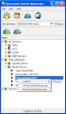
During this transition, you may need to change your default basemap in the TITAN Viewer. You can do this by following these simple instructions:

1. Select the Services tab in the Geospatial Instant Messenger (GeoIM)
2. Expand Map Collections/Master Server
3. Choose from three global coverages:

  • Topography_003.tif.lr
  • naturalearth.tif.lr
  • world.topo.bathy.200407.3x5400x2700.tif.lr

4. Right click on a coverage and select ‘Set As Default Basemap”
5. Close and reopen your TITAN Viewer (reopen Viewer from GeoIM: File/Launch TITAN Viewer)


OpenStreetMap (OSM), a collaborative global map project, will be your default basemap in a TITAN Client auto-update next week.

Thank you for being a part of the ERDAS TITAN Community!

Thursday, November 20, 2008

Professors! Hassle-free data delivery to your students!


Paul also points out that the ERDAS 2009 DVD Media Kits containing all ERDAS software and data examples for all ERDAS products are currently shipping!


Wednesday, November 12, 2008

TITAN goes Multi Screen!

This fall update to TITAN includes support for Multi Screens: spanning one TITAN Viewer display across multiple screens. In a multi-screen environment, many screens display the output of one computer and create the illusion that the numerous displays are one contiguous display. TITAN multi screen support will include both flat wall displays and also immersive environments.

Check out TITAN across 3 screens in ASU's Decision Theater:

"The ASU Decision Theater consists of an interactive 3D immersive environment
built with cutting edge graphics technologies. The core component, called the
Drum, is a 260-degree faceted screen that can display panoramic computer
graphics or 3D video content."

Look for Multi Screen support this fall as a feature in the free TITAN Client!


Tuesday, October 28, 2008

Local Government GIS Collaboration & TITAN

I had the pleasure of presenting the ERDAS TITAN solution at the Georgia URISA Conference a couple of weeks ago. This biennial statewide GIS conference is hosted by an organization dear to my heart (I served on the Georgia URISA board for five years with one term as President).

I also had the pleasure of having Joe Woycke, Cherokee County Director of GIS and Derrick Smith, GIS Manager of the City of Woodstock present after me in the same session. Joe and Derrick are working very hard to develop collaborative GIS between city and county, and in their presentation they described how TITAN proves to be 'one of the most effective means of quickly sharing and visualizing data without surrendering ownership of the data.'

Joe Woycke describing the utility of ERDAS TITAN in collaborative GIS:

County and municipal governments in Cherokee County have begun collaborating in the development of a collaborative GIS. Key to these relationships is the ability to quickly share current up to date data while retaining ownership. Many different software packages have been used to transmit and share data. ERDAS TITAN has proven to be one of the most effective means of quickly sharing and visualizing data without surrendering ownership of the data. The use of mash ups utilizing data from several different sources presented to the consumer in single client map provides great value to consumers (the taxpayers), who are not concerned about jurisdictional issues and petty parochialism. Current efforts are focused on efficiently serving and updating data with minimal overhead in terms of labor and bureauocracy, a task which TITAN is uniquely well suited for. The result is a more comprehensive GIS providing a cost savings and enhanced convenience to the citizens. Future development will be focused on providing a unified GIS to support emergency management operations, adding another aspect to the value added nature of this GIS collaboration.

Thursday, October 23, 2008

Browse TITAN Users and Data in ArcMap

Check out the new video TITAN ArcMap Extension (also available here on this blog under Product Demonstration Videos)


Browse users and load ERDAS TITAN data directly within ESRI's ArcMap. This TITAN extension to ArcGIS embeds the GeoIM as a dockable list of TITAN users and their data shares directly in the ArcMap user interface.


Extension is available here under Downloads.

ERDAS at GEOINT 2008

ERDAS will be at GEOINT 2008 Symposium, October 27-30, 2008 at the Gaylord Opryland Resort and Convention Center in Nashville, Tennessee. ERDAS and Oracle will be co-hosting the welcome reception, in the plaza between the Grand Ole Opry and the Grand Ole Opry Museum, on October 27 from 7-9 p.m.

Exhibiting in Booth #942, ERDAS is featuring ERDAS TITAN along with recently announced ERDAS APOLLO 2009 and the latest releases of ERDAS IMAGINE and LPS. Stop by the booth for demos of all the latest TITAN features.

Thursday, October 9, 2008

TITAN in Italy

In their October 2008 newsletter, ERDAS Italian distributor Planetek Italia writes:

ERDAS TITAN: the Italian Geospatial Community

The TITAN Network has its Italian Geospatial Community. Through its webportal, enriched with several tools such as forum, news, a geodata section and tutorial, Italian business professionals and surfers can rapidly learn, download and use ERDAS TITAN, connecting to the Italian GeoHub. The application is designed for those organizations and working groups who need to share geospatial or location-based contents in a single secure environment and want to benefit from real-time interaction. For Italian users, details and download are available at: http://titan.planetek.it/


We're proud to have the Planetek Italia GeoHub on the TITAN Network!