
Roger Longhorn of GEO:connexion attended the first TITAN webinar on Thursday September 25. He has written a review about what was presented, as well as posted the link to play the webinar: http://www.geoconnexion.com/geo_news_article/ERDAS-TITAN-Webinar/4387.
The webinar link is: https://erdasevents.webex.com/erdasevents/lsr.php?AT=pb&SP=EC&rID=1118387&rKey=CD2648A78BC12F1C
Tuesday, September 30, 2008
See the Webinar Here

Wednesday, September 17, 2008
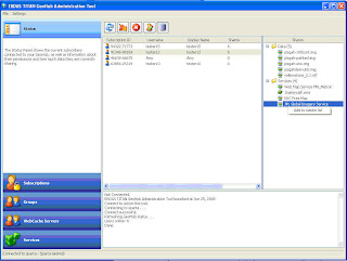
Running the TITAN Client in Linux
TITAN is about sharing data and even brings a lot of the DNA from social networking websites into the realm of geospatial data sharing. The value of a social network lies in the number of people who are able to access it and participate in discussion. Linux OS is frequently used for a variety of scientific applications which produce geospatial data. So given these facts we wanted to see if the TITAN Client would run on Linux, and begin to include the community of geospatial people using Linux on the client side.
The short answer is yes, the TITAN Client will run in Linux, but it has a prerequisite. In whatever distribution of Linux you have running, you will need to have access to the Windows API within Linux. The most common way to do this is to have Wine (http://www.winehq.org/) installed. Wine is a translation layer that has been around since 1993 and allows Windows programs to be run on a Linux machine natively, not through an emulator which usually affects memory and processor usage. You can get more information about Wine from its official website, Wine HQ. There you can find instructions on how to get Wine running on your Linux machine and also how to install Windows programs through Wine, which you’ll need since the TITAN installer is Windows-only.
We went through that process using the Ubuntu distribution of Linux and successfully got TITAN running, which you can see in the screenshot below.
The process was pretty painless, which we were expecting since most of the libraries used to build TITAN originated in Linux. If you’d like to see TITAN running in Linux, but don’t want to take the time to install Linux on a spare computer, we’ve provided a virtual machine instance of the same Ubuntu Linux we used to install TITAN. To run this, you’ll need to install either VMware Player or Server (which you can download or get more information from here - http://www.vmware.com/products/player/) and download the virtual machine from our FTP Server. If you have access to an FTP client, you can go to ftp.nvs-inc.com and log in with the user name and password of "titan." If you want a direct link to the file, you can use ftp://titan:titan@ftp.nvs-inc.com/TITANLinux.zip. The file is compressed down to 952 mb and takes up a little more than 2 gb when it's completely uncompressed, so it will take a while to download and also take up a pretty big chunk of hard drive space.
Once you’ve downloaded the zip file and extracted its contents, double-click the file named Ubuntu.vmx and VMWare should start up. You may be asked if you moved the Virtual Machine (VM), say “yes” and everything should load up just fine. The login user name and password for Ubuntu are both "user." There’s a shortcut on the desktop to start TITAN, so double-click that and you’re using TITAN in Linux (you’ll need to provide your TITAN login credentials, though).
And if you have any doubts of TITAN running in Linux, here’s a bit of trivia: the TITAN developer is named Lennox, so it should automatically work anyway. Next, we’ll try and get TITAN running on a Mac!
This article was co-written by Joel Lawhead and Joel Herr of NVision Solutions, Inc.
Joel Lawhead is the CIO of NVision Solutions, Inc. and has been involved in GIS since late 2000.
Since 2003, Joel Herr has worked for NVision Solutions, Inc., first as a GIS Analyst and currently as a GIS Specialist. He works heavily in analysis, training, production, and web application development.
NVision Solutions, Inc. is a small, disadvantaged, minority, woman-owned certified 8(a) firm specializing in advanced geospatial solutions and powerful web applications. NVision Solutions, Inc. has also assisted in several ERDAS TITAN installations and has selected it for use in emergency management and disaster recovery. NVision is headquartered at the Stennis Technology Park in Bay St. Louis, Mississippi. For more information about NVision Solutions, Inc., visit www.nvisionsolutions.com.
Friday, September 5, 2008
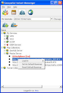
Map Collections, Server Side...
Via a TITAN GeoHub, organizations can now provide web service layers as maps to their subscribers via Map Collections.
The GeoHub Admin can add layers from WMS, WCS and ECWP to the Map Collection, and can provide access to ERDAS Apollo Image Manager (EAIM) catalogs of data exposed as web services. The Admin can also add web service layers and datasets that are published by the subscribers themselves, with permissions on those datasets maintained.
In an autonomous network, the Master Server Admin is enabled to provide layers from WMS, WCS and ECWP sources in a Map Collection as well. Beyond that, Master Server Admins can create custom tiled versions of imagery and terrain datasets for delivery from standard web servers to TITAN Clients participating in their network. They can pre-process their own basemap imagery for faster streaming of data via a custom TITAN Tiled Basemap, and can also generate a TITAN Tiled Terrain source, a custom tiled version of a terrain source which can be streamed to clients on a block by block basis.
Ultimately it’s the users that benefit from these sources of data, with more selection for basemaps and terrain for their TITAN Viewer.
Thursday, September 4, 2008
Upgrade!
The ERDAS TITAN Network was upgraded last night to ERDAS TITAN 2009! This means that your ERDAS TITAN Client will have updated too with great new features!
I am also pleased to inform you of the upcoming release of ERDAS TITAN 2009 (version 9.3) server products, including ERDAS TITAN GeoHub, ERDAS TITAN Master Server and ERDAS TITAN Web Cache Servers, which will be available early September.
Here's what's new in the ERDAS TITAN Client
- ERDAS Apollo Image Manager (EAIM) Catalog support for authenticating with and querying, discovering and accessing data as web services from ERDAS Apollo Image Manager (EAIM) Catalog.
- Data format support is extended for a select set of ERDAS IMAGINE raster formats and sensor models, available when ERDAS IMAGINE 9.3 is installed on the same machine. Support includes NITF and also TFRD (TFRD when Defense Productivity Bundle is also installed).
- Localize the TITAN Client to different languages. The TITAN Client comes equipped with a Translator Tool for any language, and is now already localized for some languages.
- Utilization of Basemaps and Terrain: GeoHub Admins can designate different sources of basemaps for their subscribers, and Master Server Admins can designate different sources of basemaps and terrain for network users. So, TITAN users may now utilize different sources of basemaps and terrain in TITAN Viewers!
And more....
- ECWP faster implementation, for fast reading of ECWP.
- Proxy file load for direct data load into ERDAS IMAGINE Viewer
- TITAN Viewer Layer panel redesign shows data owner and permissions.
- The TITAN Viewer now supports KML with color styles, placemarks, geometry, regions, stylemaps, and network links.
- Uniform styles management across applications
- Right click to create one web service with all the layers a user is sharing, or just with a selected file.
- Search results include private data and KML
- Password management
- Band combinations may be adjusted for raster datasets in the IM, for individual or multiple datasets at a time.
- Disable 2 standard deviation preference
- Start IM in tray preference so that TITAN starts minimized to the tray when Windows starts.
Get the download here. Work is still being finalized on a new ERDAS website, and currently the redirect is still to our former incarnation 'Leica Geosystems Geospatial Imaging' for now.
Subscribe to:
Posts (Atom)

